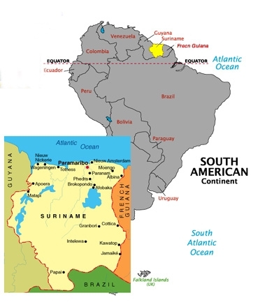
Where is Suriname? [see map] So just where is Suriname? Suriname is located between Guyana to the west and French Guiana to the east, on the coast of the Atlantic Ocean/ Caribbean Sea, north of Brazil. The shoreline, home to giant green turtles, is mostly mud flats and mangrove trees. Most of the country is covered by rainforests or jungles which are accessible by riverboat or air. Suriname is located in one of the most meteorological and seismological stable locations in the world - no hurricanes or earthquakes occur here. Suriname was a Dutch colony from the 1663 when it was part of the Treaty of Ghent settlement with the British. The Dutch traded Manhattan for Suriname. In the 1950's it received commonwealth status. It gained its independence in 1975. After a military coup on February 25, 1980, there was military rule until November 25, 1987. Currently, the democratically elected government has been taking steps to boost the economy of the country. The economic downturn had its advantages in that the instability of the government made it impossible to exploit the rainforest. Ecotours are now being promoted. Bauxite mining has been the mainstay of the export economy. I was in the capital city, Paramaribo (say: pear-uh-mare-i-boe). I was assigned to this country by the Network of International Christian Schools when they needed to fill an immediate vacancy. At first I was sent to Kunming, China, but later they called me and told me that I was needed more urgently at the American Cooperative School in Suriname. To see where I am, see the map below! | ||
 | ||